Texas Historical Marker Guide version 1.1 now available!

In my previous post, I said I would continue the narrative started in that post.  Because of the timing of the release of the next version of Marker Guide, I’ve chosen to postpone the continuation of that narrative until my next post.  For this post, I’m going to instead announce the availability of version 1.1 of Texas Historical Marker Guide.  Keep reading to find out some of its new features and improvements.

TURN-BY-TURN DIRECTIONS
Marker Guide could already initiate directions to markers with a coordinate. Now, if the marker lacks a coordinate but has complete street address information (street, city, ZIP code) you can get directions to that street address. If a marker has both a coordinate and street address, directions will be given to the street address.

LANDSCAPE ORIENTATION
Support for landscape orientation has been enhanced. For instance, when viewing a list of markers related to a county, the id number; marker type; and year are displayed under the title. After rotating to landscape, the dimensions and distance/direction from current location are added (if available.) You will find similar additional information being displayed in various places throughtout Marker Guide when rotating to landscape.

MARKER DEDICATION CEREMONIES
Marker Dedications have been expanded. Previously, when tapping a table row in the dedications list, a detail of the marker was presented. Now, the details for that event will be presented which will include the time, description, location, and RVSP/contact information if available. The Upcoming Dedications list gives you the option of being notified when dedication ceremonies are starting. You can also add dedication events to your iPhone’s built in calendar.

Many marker dedications have been and continue to be added to the database. Now you can see which new markers have been and will be revealed up through October.

Please note that dedication dates, times, and locations are subject to change without notice. Please check the Texas Historical Commission’s online calendar of events and/or your local county historical commission’s calendar for the most up-to-date information.

TEXAS GEOGRAPHICAL REGIONS
Browse markers by major geographical region. Texas is divided into anywhere from five to seven major geographical regions. The Gulf Coast; Hill Country; Panhandle Plains; Pineywoods; Prairies & Lakes; South Texas Plains; and Big Bend Country are included as browsable regions.

DATABASE UPDATES
With cooperation from the Texas Historical Commission, hundreds of new markers have been added to the database including titles up through 2014 and 2015.

PLACES OF INTEREST
Many places of interest have been to the database for a grand total of just over four hundred listings. Finding new places of interest to include in the database is an ongoing process.

NEW NARRATIVES AND NEWLY LOCATED MARKERS
Added new data such as coordinates and narratives to many markers already in the database. Our database contains over 16,000 historical marker records. Checking each record for accuracy and making corrections is an ongoing process.

BUG FIXES
1. Fixed an issue which caused Marker Guide to crash when unflagging a marker.

2. Fixed an issue which caused unflagged markers to be flagged again when switching away from Marker Guide and back again.

3. Did some major refactoring “under the hood” to make Marker Guide more reliable and more easily expandable.

4. Marker Guide has always been able to display the user’s current location on its maps- as long as it is allowed to use Location Services. However, upon reexamining the flow of the app, we found it was possible to get the app into a state with Location Services unauthorized and no indication from Marker Guide as to the reason for not displaying the user location on a map.

Two things have been done in an effort to fix this:
a) The explanation about what Marker Guide uses Location Services for has been more explicitly stated in various places.
b) When viewing a map when Location Services have been unauthorized, an alert will be displayed to notify the user their location cannot be displayed and the reason why. We hope this gets Texas Historical Marker Guide closer to the “Golden” status we aspire to reach.

LEAVE A REVIEW
Are you using and enjoying Texas Historical Marker Guide? Please leave a review and let us know your thoughts.

App Store Badge

Why Texas Historical Marker Guide? Part 1 of 2

So you ask, why Texas Historical Marker Guide? The answer has two parts. The first part is this: I want to help you find historical markers. And the second part? I want you to help me find historical markers. And by helping me find markers, you also indirectly help other users find them. I’m going to expand on the first part in this post.

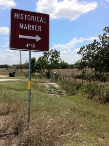
As a child I went on road trips with my family and I can still remember seeing those brown signs by the road. Historical marker 1 mile ahead. Texas historical was still fresh on my mind from school, so I thought wow, Sam Houston or Santa Anna must have been there. That was all I knew about Texas history back then, so that must have been what the marker was about right?

But we never stopped. So I never found out.

Later in life, I remembered those brown signs and one day… I stopped.

I learned about dairies in the Hitchcock vicinity. The subject was a little more obscure than I had expected, but there was something about it. There were at least a couple other markers on the same road, so we stopped at those too. Pretty soon I realized, if I took a picture, I could read it later when more time was available. And after so many pictures of just marker text, I realised they were meaningless unless I could remember exactly where they all were. So I started taking two or more pictures. One close up and at least one from farther away.

I can still remember seeing those brown signs by the road.

And I began thinking… am I the only one who pays attention to these things? And the answer is… no. After seaching on Google Images over the years for pictures of markers, I began getting more and more relevant results. One lady, Marion, has traveled what seems like the majority of Texas snapping pictures of every marker she can find. She shares them on Flickr and I’m very grateful for that. Other people share their findings on Waymarking.com, a site designed for sharing the location of anything interesting including historical markers. It even has a Texas Historical Markers group. HMDB.org specializes in historical markers. Anybody can sign up for an account and share the markers they have found.

Search long enough and you will probably come across the Texas Historical Commission’s online Atlas. The THC is the official state agency for overseeing historical preservation. The Atlas contains data on historic sites and markers all over the state. Each county also has its own county historical commission which governs historical preservation for that county. Many them have their own online marker inventory. One excellent example is the one for Harris County.

Wouldn’t be great if all the data found on all these websites could gathered in one place? And wouldn’t it be great if access to that data were portable? Some people are apparently interested in historical markers, so maybe there should be an app for that. Yes and yes. And now it is. And now there is. Texas Historical Marker Guide.

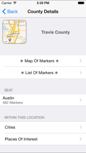
Texas Historical Marker Guide (or Marker Guide for short) makes it easier to find historical markers in Texas. For instance, when we think about historical markers, it seems most common to think of them in terms of which county they’re in. That is why Marker Guide will display your current county right at the top of the very first screen. Marker Guide must be allowed to use Location Services for this to happen but it does help you browse more quickly. Of course you can browse any county you want by viewing the list of counties.

County Detail View
County Detail View

Once you find your county, it is simple to view a map or list of all markers in that county.  The list is useful because for some markers, we don’t have the coordinates.  More on that in the next post. When viewing the details of a marker, if that marker has a coordinate associated with it, you can get turn by turn driving directions to that coordinate. And hopefully that’s where the marker really is. If you found the marker, you might want to check-in.  Markers you check-in at display a green check mark badge. Over time, you can see where all you’ve been.

Definitely take some pictures. You can even link them to the marker they depict. But be warned. Emptying your camera roll may remove those photo links from Marker Guide. Marker Guide also provides the functionality to delete photo records from its own database but it does not remove photos from the camera roll.

Now, what if you didn’t find the marker? The detail of the marker might give a street address. So you could try that. For now, you’ll have to type it manually into your favorite map app. Many times coordinates are unavailable. Sometimes they are “available” but incorrect. Sometimes, the coordinates are correct, but the marker has disappeared. Sometimes, the marker gets relocated but nobody gets notified. My next post will address the situations mentioned above.